여러분이 방문해볼 필요가 있는 세계 10곳의 정말 놀라운 자연적
기이함
By Amy Grisdale, How It Works magazine 13 days ago
13일전 잡지에서 그것이 작용하는방식에 관한
에이미 그리스데일씨에 의한 글
Some of the best locations nature has to offer, from an island
teeming with "dragons" to a famous waterfall.
최고의 장소의 자연적 현상중 몇 곳은 섬으로부터 제공되어진다.
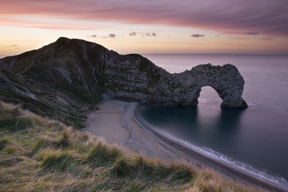
Jurassic Coast, United Kingdom
영국의 쥬라기 해변
(Image credit: Getty Images )
(이미지 저작권: 게티 이미지)
There are 185 million years of history hidden along the south coast of England,
in the United Kingdom.
Paleontologist Mary Anning made game-changing discoveries of prehistoric remains
along this coastline in the early 1800s.
영국에는 일글랜드 남해안을 따라 감추어진 1억 8천 5백만년의
역사가 있다.
고생물학자 메리 애닝씨는 1800년대 초 이 해안선을 따라 판도를
뒤바꾸는 선사시대의 유적을 발견했다.
According to the Smithsonian, the shores of Devon and Dorset used to lie under
the sea where Morocco sits today.
Before the continents completely drifted apart this region was a hotbed of pre
historic life. Over thousands of years,
animal remains became imbedded in sediment that eventually hardened to stone.
스미스소니언 사람들에 따르자면, 데본과 도싯해안은 과거 한때는
오늘날 모로코가 있는 바다아래였다,고 한다.
대륙이 완전히 떨어져나가 표류하기전애 이 지역은 선사시대 생활
의 온상이었다.
수천년에 걸쳐 동물의 유골들이 결국 돌로 딱딱하게 굳어 퇴적물
로 고착되었다.
Today this area is battered by coastal waves, but new fossil discoveries are still being
made: finds range from small curled ammonites to 33-foot-long (10 meter) ichthyosaurs,
according to the BBC.
오늘날 이 지역은 해안의 파도에 의해 휩쓸리게 되지만, 그러나
새로운 화석의 발견은 디음 내용처럼 여전히 이루어지고 있다:
BBC에 따르자면, 작은 암모나이트류에서 33푸트 길이(10미터)의
소멸된 바다 파충류 아이히로사우르스를 그 범위로하여 발견되어
진다, 고 한다.
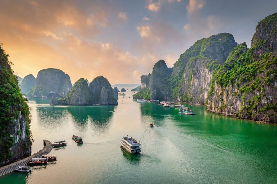
Ha Long Bay, Vietnam
베트남 하롱베이
(Image credit: Getty Images )
(이미지 저작권: 게티 이미지)
There are around 1,600 islands nestled throughout this 580-square-mile (1,500
square kilometers) bay in the Gulf of Tonkin, Vietnam.
A layer of limestone slowly developed over 500 million years, and by the end
of the Permian Period, 251 million years ago, it was 3,280 feet (1,000 meters) thick.
베트남의 통킨삼각해협에는 580평방 마일(1,500평방 킬로미터)
의 만을 통하여 약 1,600개의 섬들이 자리하고 있다.
2억 5천 1백만년 전에 페름기의 말까지 5억년에 걸쳐 석회암층이
느리게 개척되어 그것의 두께가 3,280피트(1,000미터)나 되었다.
The hunk of rock was then weathered by the sea, but really took a beating in the
last ice age. The slab broke apart, and the fragments are the islands we see today.
Around 1,600 people live in floating fishing villages rather than disturb the pristine
islands, while tourists sleep on board boats during their visit, according to Lonely
Planet.
바위덩어리는 그때의 바다에 의한 기상상태에 의했지만, 그러나,
실지로 마지막 빙하기를 지나면서 큰 타격을 입었다.
그 바위덩어리는 떨어져 나가서, 그리고 그 조각들은 우리가
오늘날 보고있는 섬들을 이룬다.
가이드 서적인 론리 플래닛에 따르자면, 약 1,600명의 사람들이
그 청정섬들을 어지럽히기보다는 다소 떠다니는 어업마을에
살고 있고, 관광객들은 그들의 방문중에 배를 타고 잠을 즐긴다,
고 한다.
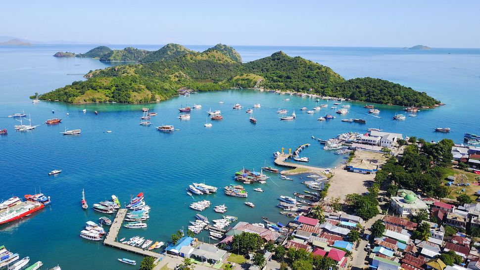
Komodo Island, Indonesia
인도네시아 코모도 섬
(Image credit: Getty Images )
(이미지 저작권: 게티 이미지)
Famous for its giant lizards, this volcanic island in is part of the Lesser Sunda Islands. Komodo dragons are the largest living lizards on Earth today.
그것의 거대한 도마뱀으로 유명한 남부 인도네시아의 이 화산섬은
소순다 제도의 부분이다.
코모도섬의 용은 오늘날 지구상에 살고있는 가장 큰 도마뱀이다.
They came from Australia and are descendants of the biggest lizards known
to science, according to the Guardian.
With no other predators on the island, Komodo dragons were able to thrive,
but eventually most of the native prey disappeared, so they now eat animals
that have been introduced to the island, ranging from rats to water buffalo.
감시인에 따르자면, 그들은 오스트리아에서 왔고, 그리고 과학적
으로 알려진 가장 큰 도마뱀의 후손들이라 한다.
그 섬에는 다른 아무런 약탈자가 없는 사실과 더불어, 코모도 용은
번창할 수 있었지만, 결국에가서는 그 원주민의 먹이감은 대부분
사라지게 되었는데, 그래서 지금 원주민들은 쥐에서 물소를 범위
로하는 그 섬으로 유입되어지게된 동물들을 먹이감으로 한다.
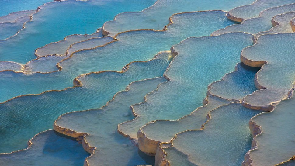
Pamukkale, Turkey
터키의 파묵칼레
(Image credit: Getty Images )
(이미지 저작권: 게티 이미지)
Pamukkale means “cotton castle.” Hot water flows down from a cliff-top spring 655
feet (200 meters) from the ground. The water comes out warm when it originates
from a spring 1,050 feet (320 meters) underground.
파묵칼레란 "솜으로 된 성"을 의미한다. 온수가 지면으로부터 655
피트 (200 미터)의 절벽 꼭대기의 샘에서 떨어진다.
그 물은 그것이 1,050피트 (320미터)지하의 샘으로부터 생겨날 때
따뜻하게 나온다.
As water leaves the spring it makes contact with the air for the first time and
begins to change. Initially, it’s fully saturated with minerals, but a chemical re-
action causes it to release carbon. As this process happens it leaves a coating
of crystals behind. Pamukkale boasts petrified waterfalls, mineral forests and
terraced basins, according to UNESCO.
물이 그 샘을 떠날 때, 그것은 처음으로 공기와 접촉하여 그리고
는 변화가 시작된다.
처음에 그것은 여러가지 광물과 더불어 완전히 포화상태가 되
지만, 화학적 반응으로인하여 그것은 탄소를 방출하게 된다.
이러한 작용이 발생될 때, 그것은 뒤에다 크리스탈 코팅물질을
남기게 된다. 유네스코에 따르자면, 파묵칼레는 광기어린 목포,
광물질 숲, 그리고 계단식 분지를 자랑하고 있다, 고 한다.
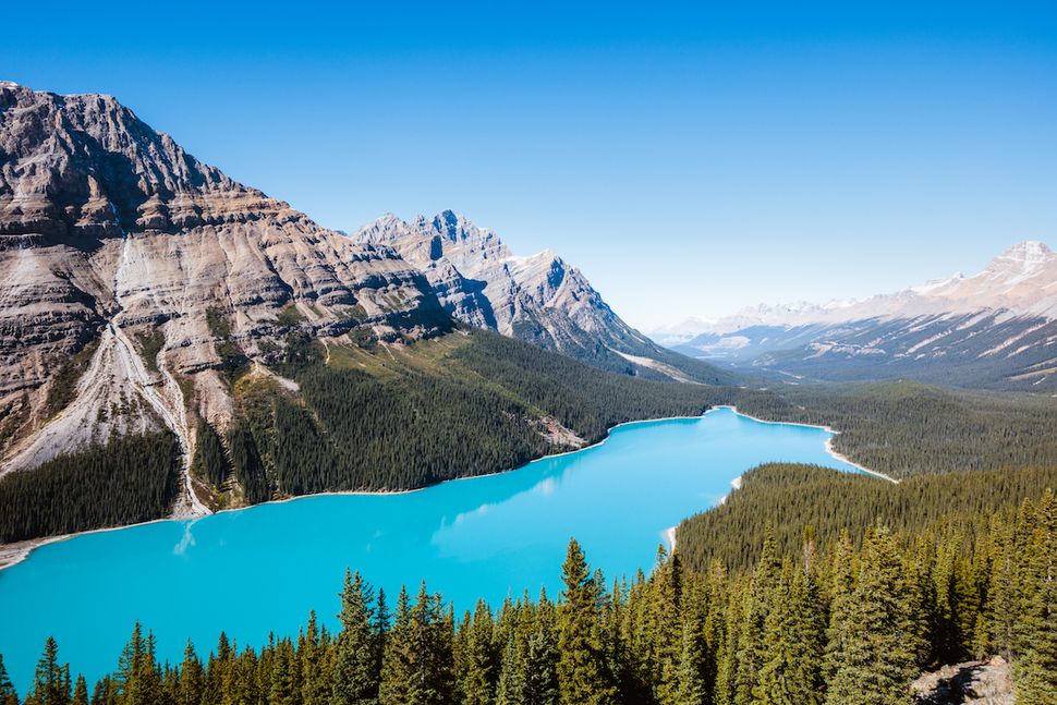
Peyto Lake, Canada
캐나다의 페이토 레이크
(Image credit: Getty Images )
(이미지 저작권: 게티 이미지)
This gorgeous lake is in Banff, the oldest national park in Canada. It’s fed by active
glaciers high up in the Canadian Rockies. Flowing glaciers scrape away fragments
of rock as they advance.
이 멋있는 호수는 캐나다에서 가장 오래된 국립 공원 뱀프
관광지내에 있다.
이것은 캐나다 로키 산맥에 우뚝 솟은 원기왕성한 빙하에
의해 그 먹이감이 된다.
흐르는 빙하는 그것들이 앞으로 나아갈 때 바위조각들을
긁어댄다,
The places where the ice touches the rock is wet and slippery, helping water
to wash bits of rock down to sea level underneath the frozen river.
The dust from this rock reflects blue light, according to Earth Science Picture
of the Day, and so our eyes see the water as a vivid turquoise.
This effect is strongest in the summer when glaciers melt fastest.
빙하가 그 바위와 접촉을 하는 곳은 젖어 미끄러운데, 물로
하여금 언강 아래의 해수면으로 떨어뜨리는 바위조각들을
씻어주는 보조작용을 하게끔한다.
오늘의 지구 과학그림에 따르자면, 이 바위로부터의 그 가루
는 푸른 빛을 띤다고 하며, 그래서 우리의 눈에는 그 물이 활
기로운 청록색으로 보이게 된다,고 한다.
여름철에 빙하가 아주 빠르게 녹을 때 그 작용이 가장 강하다.
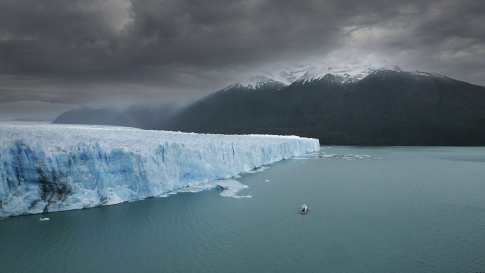
Perito Moreno Glacier, Argentina
아르헨티나의 페리토 모레노 빙하
(Image credit: Getty Images )
(이미지 저작권: 게티 이미지)
While most glaciers in the region are melting fast, this one has barely changed
in the last 100 years. It crawled forward at least 2,625 feet (800 meters) since
the late 1800s, according to a study published in the journal Scientific Reports,
and may still be advancing today. It accumulates more mass than any glacier
being monitored right now.
그 지역의 대부분의 빙하는 빠르게 녹는반면, 이러한 빙하는
마지막 100년을 지나면서는 거의 변화가 없었다.
저널 과학보고서에 발간된 논문에 따르자면, 그것은 최근
1800년대 이후로 적어도 2,625 피트 (800 미터) 전방으로
이동되었다고 하며, 그리고 오늘날 지금도 여전히 앞으로
나아가고 있다,고 한다.
그것은 지금현재 감시되고있는 어떠한 빙하보다도 더 큰
덩어리로 축적되어 있다.
The parts of a glacier that are bonded most strongly to rock are called pinning points. Glaciers
usually retreat quickly if this part of the glacier melts.
Perito Moreno is holding firm thanks to the strength of its crucial pinning points, which may
help it survive the warming climate, according to the same study.
바위에 강하게 동여매여진 빙하의 부분을 핀포인트라고 부른다.
빙하는 대개 만일 빙하의 이 부분이 녹게되면 재빨리 움추려든다.
같은 논문에 따르자면, 페리토 모레노 빙하는 그것의 결정적인
핀포인트가 억센덕택으로 확고하게 유지되고있으며, 그리고
이러한 현상은 온난해가는 기후에 살아남는 보조적 역활을
하는지 모른다고 한다.
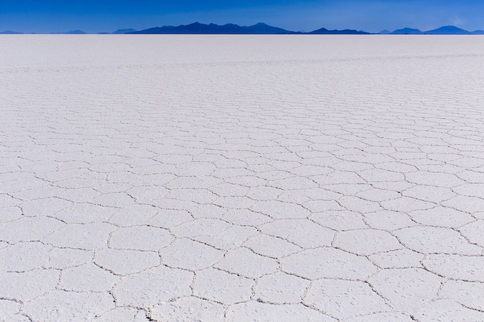
Salar de Uyuni, Bolivia
볼리비아의 살라르 데 우유니
(Image credit: Getty Images )
(이미지 저작권: 게티 이미지)
This is the biggest salt flat in the world, stretching more than 4,000 square miles
(10,300 square kilometers) and sitting at an elevation of 12,000 feet (3,660 meters).
The ground is covered by salt crust several feet thick, with a pool of salty brine
beneath.
이것은 4,000평방 마일(10,300평방 킬로미터)이상으로 길게
뻗어있는 세계에서 가장 큰 솔트 플랫(바닷물의 증발로 침전된
염분으로 뒤덮인 평지)이며, 그리고 위로 12,000피트(3,660미터)
솟아있다.
그 지반은 밑으로 염분이 많은 웅덩이와 더불어 애닐곱 피트의
두께로 윗부분이 소금으로 덮혀있다.
For thousands of years water has collected in the area to form lakes, then dried up
again. A study published in the journal Quaternary Research found that the entire
plain was permanently flooded at least four times in the last 40,000 years.
Cacti are the only plants that can grow on the salt flat, but three species of flamingo
visit for the breeding season every November.
수천년동안 많은 호수를 형성하게되는 물이 그 지역에 모여졌고,
그리고는 다시 말라붙었다.
저널 분기별 연구에 출간된 연구논문에서는, 그 전체 평지는 마지막
4,000년을 지나면서 적어도 4번이나 영원히 물에 잠기게 되었다는
사실을 발견했다, 고 한다
큐티는 그 소금 평지에서 성장가능한 유일한 식물이지만, 매년 11월
번식기동안 홍학 3종의 방문이 있다.
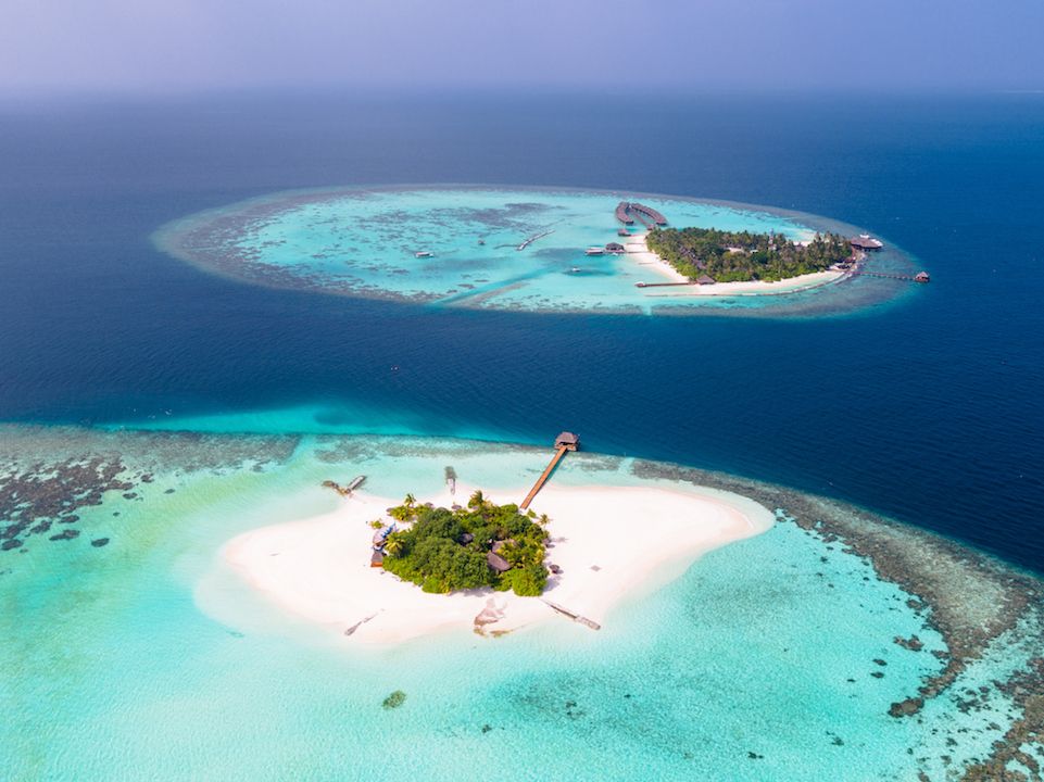
The Maldives, Indian Ocean
인도양의 몰디브
(Image credit: Getty Images )
(이미지 저작권: 게티 이미지)
The Maldives comprises 1,190 small islands in the Indian Ocean surrounded by coral
reefs. Almost 1,000 of the islands are uninhabited by humans.
Most of the sand around the world consists of rough grains of quartz, but the shores
of the Maldives are piled with soft coral sand, making them some of the best beaches
in the world, according to Lonely Planet.
몰디브는 산호초로 둘러쌓여진 인도양에서 1,190개의
섬들로 이루어져 있다.
그 섬들의 거의 1,000개는 인간이 살 수 없는 곳이다.
론리 플래닛에 따르자면, 세상 주변의 사막의 대부분은 석영 알갱이
로 이루어져 있지만, 그러나 몰디브의 해안은 그것들을 세상에서
가장 좋은 해변의 몇 개로 되게끔 하는 부드러운 산호 모래
로 덮혀있다, 고 한다.
With an average elevation of three to five feet (one to 1.5 meters) according to the High
Commission of Maldives, it’s both the lowest and flattest nation on Earth.
If sea levels rise at the rate scientists predict, much of the country could disappear under-
water by 2100, says an article published on Earth.org.
몰디브의 고등 위원회에 따르자면, 3~5피트(1에서 1.5미터)의 평균적인
고도와 더불어 그것은 지구상의 가장 낮은 국가이자 가장 평평한 나라
둘 다이다, 라고 한다.
만일 해수면이 과학자들이 예언하는 비율로 증가된다면, 그 나라의 대
부분은 2100년도쯤이면 수중으로 사라질 수도 있다, 라고 Earth.org에
출간된 한 기사항목에서는 말한다.
Victoria Falls, southern Africa
남아프리카 빅토리아 폭포

(Image credit: Getty Images )
(이미지 저작권: 게티 이미지)
These are among the world’s most famous waterfalls. Its one-mile (1.6 kilometers) width
is remarkable. The bedrock beneath the Zambezi River is basalt — volcanic rock that
formed 180 million years ago.
이들은 세상의 가장 유명한 폭포들로 손꼽힌다. 그것의 1마일(1.6킬로
미터) 너비는 장관이다.
잠베지 강 아래의 암석은--1억 8천년전에 형성된 화산암석인 현무암
이다.
The bedrock built up over a million years of gentle volcanic eruptions, and the layers
of hot lava cooled down and cracked in several places from east to west. When the
Pangea supercontinent split, the damage to the basalt worsened.
그 암석은 백만년에 걸쳐 온화한 화산의 분출로 쌓여졌으며, 뜨거운
용암의 속층은 식어서, 그리고는 동쪽에서 서쪽으로 애닐곱장소로
갈라졌다. 판게아 초대륙이 쪼개어질 때, 현무암에 대한 타격은 악화
되었다.
Tectonic plates then pushed southern Africa upwards, creating new river systems.
Victoria Falls began flowing 5 million years ago after movements underground caused
an enormous lake to start spilling over. The water quickly established a course and now
flows elegantly off the cliffs of the fractured volcanic rock.
그리고나서 구조판은 새로운 강의 기틀을 생성시키게되는 남아프리카
를 위쪽으로 밀어올렸다.
빅토리아 폭포는 지하의 움직임이 막대한 호수로 하여금 가득차넘치기
시작하는 까닭이 된 후인 5백만년전에 흐르기 시작했다.
그 물은 재빨리 진로를 정했고, 그리고 지금은 분열된 화산암석 낭떠러지
를 우아하게 흐른다
Great Barrier Reef, Australia
오스트레일리아의 대보초(大堡礁) (오스트레일리아
북동부의 Queensland 해안과 병행하는 큰 산호초)
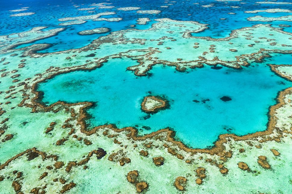
(Image credit: Getty Images )
(이미지 저작권: 게티 이미지)
Almost 3,000 individual reefs make up the biggest coral system in the world.
It’s home to 1,500 fish species, a third of the world’s soft coral and six of the world’s
seven species of sea turtle. It was established as a World Heritage Site in 1981, and
restrictions on fishing and tourism were put in place.
거의 3,000개의 암초가 세계에서 가장 큰 산호층을 이룬다.
그것은 1,500어종, 세계 연한 산호의 1/3, 그리고 세계 바다 거북 7종중
6종의 출생지이다.
그것은 1981년도에 세계 유산으로 확립되어졌고, 그리고 어업과 관광에
대한 제재장소로 놓여졌다.
Sadly, the Great Barrier Reef has lost half its coral since 1985. The damage is happening so fast scientists can’t keep up. Corals have died off because of pollution, invasive species and a process called coral bleaching, according to Science magazine. The water on the planet is simply getting too warm for corals to survive but, according to an article published by Nature on Nov. 27, 2019, scientists are protecting the more resilient reefs while nursing others back to health.
유감인건, 대보초(大堡礁)는 1985년이후로 절반이나 손실을 보였다.
그 해악은 과학자들이 유지해내기가 불가능할정도로 아주 빨리 발생
하고 있다.
과학 메거진에 따르자면, 산호들은 오염, 산호 표백이라고 일컬어지는
과정인 침입종, 때문에 죽었다, 라고 한다.
2019년 11월 자연에 출간된 한 기사거리에 따르자면, 지구상의 물이
산호들이 살아가기에 단순히 너무 뜨거워진 것 뿐만이 아니지만, 과학자
들은 나머지 산호의 건강회복을 위하여 치료해가는 반면 더 저항력 있는
산호를 보호해나갈 작정이라고 한다.

댓글 없음:
댓글 쓰기