과학자들은 세상의 가장 차가운 구름이 태평양 바다 위를
떠나니는 것을 탐지하게된다.
By Yasemin Saplakoglu - Staff Writer a month ago
1개월전 전속작가 재스민 사플라코글루에 의한 글
The top of the storm cloud reached the stratosphere.
그 폭풍우를 담은 구름의 꼭대기부분은 성층권에까지
이르른다.
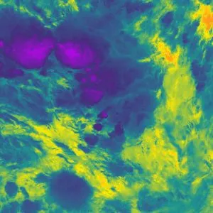
Storms near Nauru on Dec. 29, 20118 captured in infrared by an orbiting satellite.
The cold parts of the clouds are in purple and the warm Pacific Ocean is in orange.
(Image credit: National Centre for Earth Observation)
2018년도 12월 29일 나우루근처의 폭풍우는 궤도를 순환하는
위성에 의해 적외선으로 포착된다.
그 구름의 차가운 부분은 자줏빛이며 따뜻한 태평양은 오렌지색
을 띠고 있다.
(이미지 저작권: 국립 지구관측 센터)
A severe thunderstorm cloud that formed over the Pacific Ocean in 2018
reached the coldest temperatures ever recorded, according to a new study.
새로운 논문에 따르자면, 2018년도에는 태평양위로 형성되었던
심각한 뇌우 구름이 여태 기록되었던 가장 차가운 기온에 도달
한다.
The very top of the storm cloud reached a bone-chilling minus 167.8 degrees
Fahrenheit (minus 111 degrees Celsius), colder than any storm cloud measured before.
Thunderstorms and tropical cyclones, a circular low-pressure storm, can reach very high altitudes
— up to 11 miles (18 kilometers) from the ground —
where the air is much cooler, according to a statement from the U.K.'s National Cente
r for Earth Observation.
폭풍우 구름의 가장 꼭대기 부분은 예전에 측정된 어떠한 폭풍우
구름보다도 더 차가운뼈속까지 으스스한 마이너스 167.8도에
이르게 된다.
뇌우와 그리고 열대성 저기압인, 순환 저기압 폭풍우는-- 지상
으로부터 11마일(18킬로미터)까지의-고도에 도달하게 되는데--
U.K.'의 국립 지구관측소로부터의 자료에 따르자면, 그곳에서의
공기는 훨씬 더 차갑다고 한다.
But this new temperature is on another level. The top of the storm cloud was
about 86 F (30 C) colder than typical storm clouds, according to the statement.
The beast of a storm loomed about 249 miles (400 km) south of Nauru
in the Southwest Pacific on Dec. 29, 2018, and its clouds' temperature was picked up
by an infrared sensor aboard the U.S.'s NOAA-20 satellite orbiting the planet.
그러나, 이 새로운 기온은 다른 수준상에 있다. 그 자료에 따르자면,
그 폭풍우 구름의 꼭대기 부분은 열대성 폭풍우보다 더 차가운 약
화씨 86도(섭씨 30도)라고 한다.
폭풍우의 급습이 2018년 12월 29일 남서태평양에서 나우루 약 249
마일 남쪽에 어렴풋하게 나타나는데, 그것의 구름의 온도는 지구궤도
를 도는 미합중국의 노아-20위성에 설치된 적외선 센서기에 감지
된다.
Related: 10 science records broken in 2020
관련내용: 2020년도에 깨지게된 10개의 과학적 기록
Storms typically spread out into an anvil-like shape when they reach the top of the troposphere,
the lowest layer of Earth's atmosphere.
But if a storm has a lot of energy,
it will shoot into the next layer, the stratosphere.
This phenomenon, known as an "overshooting top," pushes storm clouds to very high altitudes,
where it's bitterly cold.
폭풍우는 첨단적으로 그것들이 지구의 대기의 가장 낮은 층인 대류권의
꼭대기에 도달하게되면 모루와 같은 형상안으로 확산하게된다.
그러나, 만일 폭풍우가 많은 에너지를 지니고 있으면, 그것은 그 다음층인
성층권으로 발진하게 된다.
"과행(過行)탑"으로 알려진 이러한 현상은 폭풍우 구름을 매우 높은 고도
까지 밀어부치게되며, 그곳에서의 그것은 몹시 차갑다.
Overshooting tops are "reasonably common," lead author Simon Proud,
a research fellow at the National Centre for Earth Observation and at Oxford University told the BBC.
Typically, an overshooting top cools by about 12.6 F (7 C) for every kilometer it rises in the stratosphere,
he said.
과행탑 현상이 "이치적으로 보편적"이다, 라고 국립지구관측 센터와 옥스
포드 대학의 연구조사원이자 선임 저작자 시몬 프라우드씨는 BBC에
말했다.
첨단적으로 과행탑에서는 그것이 성층권에서 상승되는 매 킬로미터당
화씨 약 12.6도(섭씨 7도)치 냉각된다.
But this storm was particularly extreme.
"This storm achieved an unprecedented temperature that pushes the limits of what current satellite sensors are capable of measuring,"
Proud said in the statement. "We found that these really cold temperatures seem to be becoming more common."
그러나 이 폭풍우는 아주 극적이었다.
"이 폭풍우는 현재의 위성 센서기가 측정할 수 있는 한계치로 쇄도해가는
전례없는 온도에 도달했습니다,"
라고 프라우드씨는 그의 저서에서 말했다.
"우리는 실지로 이것들 차가운 온도가 더 보편적으로 되어지는 것처럼
보이는 것을 발견하게 되었습니다."
In the last three years,
scientists have logged the same number of extremely cold temperatures in clouds as they did in the 13 years before that, he added.
"This is important, as thunderstorms with colder clouds tend to be more extreme, and more hazardous to people on the ground due to hail, lightning and wind."
최근 3년을 지나면서, 과학자들은 상기의 내용전의 그것들이 13년
이라는 기간에서 그러했던 것처럼, 구름에서도 극도로 차가운 기온과
같은 수치를 기록하게되었다, 라고 그는 덧붙여 말했다.
"이것은 중요한 사실로써 더 차가운 구름으로된 뇌우가 더 극적이면
극적인 경향일수록 점점 더 지상에서의 사람들에게는 우박과 번개와
바람으로 인하여 위험스러워진다는 겁니다."
This particular storm may have been energized by a combination of very warm water in the region and eastward-moving wind, according to the BBC.
However, it's not clear why these colder temperatures in storm clouds are becoming more common.
BBC에 따르자면, 이 특정 폭풍우는 그 지역에서의 매우 따듯한 물과
그리고 동쪽으로 향하여 움직이는 바람의 조합에의하여 활기를 띠게
되었을런지도 모른다, 고 한다.
그러나, 폭풍우 구름에서의 이것들 더 차가운 온도가 왜 더 보편적
으로 되어가고 있는가하는 이유는 분명하지 않다.
"We now need to understand if this increase is due to our changing climate or whether it is due to a 'perfect storm' of weather conditions
producing outbreaks of extreme thunderstorms in the last few years," Proud said.
"우리는 지금 이러한 증가치가 우리의 변화되어가는 기후에 기인하는지
혹은 그것이 최근의 약간의 년도에서 극도의 뇌우의 발생을 생성시키게
되는 기상상태의 '완벽한 폭풍우'에 기인하는지 어떨지를 이해하는 것이
필요합니다," 라고 프라우드씨는 말했다.
The findings were published March 22 in the journal Geophysical Research Letters.
그 발견내용은 3월 22일자 지구물리학 연구논문집에 실렸다.
Originally published on Live Science.
라이브 사이언스에 원본으로 출간됨

댓글 없음:
댓글 쓰기